To see this page in your own language use the following translation bar.
Geocaching software
by halcongris
![]() Click on the geocaching.com icon for geocache locations in Spain. You will need to register for a free account at geocaching.com to see the maps.
Click on the geocaching.com icon for geocache locations in Spain. You will need to register for a free account at geocaching.com to see the maps.
I have collected here some links to software you will need if you want to use your PC to make the geocaching experience easier and more fun. The software is all either freeware or shareware with a free version that is useful and doesn't expire. I outline the advantages of paying to register the shareware versions where appropriate.
Happy geocaching!
Using Maps To really enjoy geocaching with your GPS, a program that allows you to display maps and plot your route and caches is a great idea. Without a doubt, the best program available is OziExplorer. You can display your map, download the cache location from geocaching.com and display it on the map, plot a route and then download the route and cache location to your GPS. Print out a copy of your map and off you go! Then when you return home, use OziExplorer to download the track recorded by your GPS and plot it on the map again to see where you actually went! The freeware version of OziExplorer has some limitations but is very useable. When you download the free version you also get a trial version of the full package which can be used to see what you are missing in the free version. I recommend you get the free version working first, and try it out on a couple of caches. Then try the trial version to see what you get in the paid version. My guess is that once you have done a few caches you will decide to spend the £55 it costs to buy the full version. Money well spent. But first, download the free version.
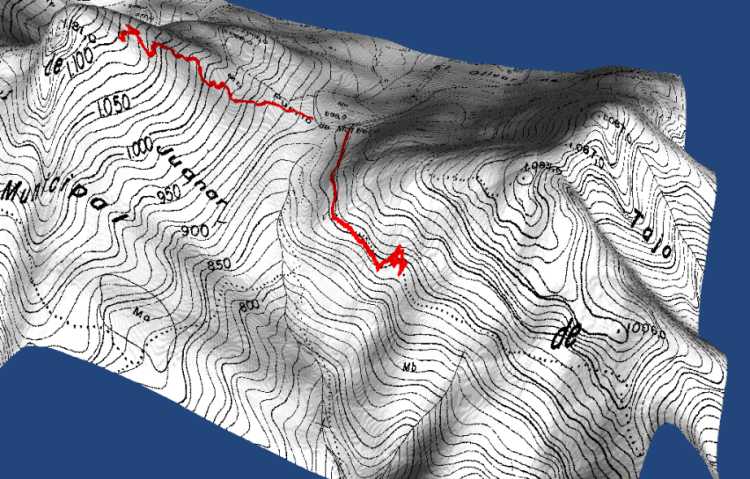
3D Maps There is an add-on for OziExplorer called OzExplorer3D which allows you to go one step further and create 3-dimensional maps showing the route you plan (or the route you took, or both). You need a map and the altitude data for the region of the map. This altitude data can be obtained free from the internet and full instructions are given in the tutorial included with OziExplorer3D. I have produced a small example of the output from when I went to the Cruz de Juanar just outside Marbella. You will see that I turned back just before reaching the top. This was owing to bad weather, it was actually snowing!.
Designated trademarks and brands are the property of their respective owners.
The Groundspeak Geocaching Logo is a trademark of Groundspeak, Inc. Used with permission.
This document was last updated 31 July 2019

© 2019 Graham G Hawker
Privacy Policy